Land
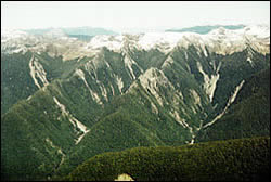 |
Erosion in upper catchment |
Introduction
Rainfall is strongly modified by the land on which it falls. Vegetation and soils retain, absorb, and retard rainfall as it travels to streams and rivers. Consequently, the characteristics of rain "flow" differ substantially from the characteristics of river flow.
Similarly, the chemical composition of rain water changes as it comes in contact with vegetation, soils, and rocks on its way to rivers. It makes sense then, that different types of vegetation, soils, and rocks should influence the quantity and quality of river water differently. This will be true no matter how the land is used. However, it is also clear that if the same land is used differently - for example, as farm land rather than native bush - one might expect the quantity and quality of river flow to differ in response. Some of these change may be acceptable and others may not.
Deciding how changes in the land will affect the characteristics of streams and rivers - and the coastal areas into which they flow - is a difficult task. It is especially difficult if the land characteristics and the land use patterns are complicated, as is almost always the case in large regions.
Successful management of these challenges requires an appreciation for a wide range of physical, biological, and chemical processes and the ways in which they interact.
The purpose of this theme in our programme is to develop a firm understanding about the influences that past, current, and future land uses have on the quantity and quality of water in the Motueka River.
Researchable Issues
- How does land cover affect surface flows and groundwater recharge?
- Does groundwater withdrawal affect stream flow?
- Has water availability changed substantially from past conditions?
- Is water availability likely to change substantially with future development?
- How do land form and land use interact to influence water quality?
Research Areas
-
Dating groundwater
Knowing some thing about the age of water in groundwater aquifers is important for managing the resource. -
Farm environmental planning
This research demonstrates and documents a collaborative approach to landowner environmental planning for all productive land uses within a sub–catchment -
Fine sediment: bringing the geomorphology and biology together
Suspended sediment effects on freshwater and coastal habitats. -
Forest harvesting effects
The potential for erosion and sediment generation within forests is one of the major environmental effects facing the forest industry in New Zealand. In particular, the harvesting phase has the potential to cause a range of environmental impacts many of which are manifested off–site in streams and estuaries. -
Gravel extraction
-
Mechanisms of groundwater recharge
Understanding recharge processes of aquifers is important because many aquifers are now largely fully allocated for irrigation and continued availability of groundwater is dependent on annual recharge of these aquifers. -
Riparian classification
Reconaissance level mapping of the Motueka catchment used to develop a classification or typology to be used for understanding the current status and function of riparian margins throughout the catchment. -
Riparian vegetation assessment
Riparian native plant biodiversity within the Motueka River catchment is generally poor, at least in the managed parts of the catchment (i.e., outside the DOC estate). In order to improve things it is important to know what´s there and where the best opportunities exist for enhancing native vegetation. -
Riparian vegetation enhancement
This work is aimed at enhancing native vegetation biodiversity in weedy environments such as those in the Sherry River. -
River bank styles
-
Sediment generation, delivery and impacts
Sediment may have a range of impacts on the ecology and habitat of both freshwater and marine ecosystems. To understand and manage these impacts it is important to determine the major sources of sediment generation as well as establish changes in riverbed characteristics important to maintenance of the trout fishery, and delivery of sediment to the marine environment. -
Stabilising characteristics of native plants
Provides information on the below–ground characteristics (roots, architecture, strength, biomass) of New Zealand native plants. -
Tall vegetation effects on water yield
A decision support system has been developed to assist land managers in assessing possible changes in water yield from a catchment with a change in vegetation cover. -
Upper Motueka water resources
Knowledge of the location and size of aquifers and the linkages between surface processes and groundwater and between the rivers and groundwater are important for making decisions on water allocation. -
Water augmentation
Reports from studies looking at water storage and augmenting summer flows to meet irrigation demand.
 |
 |
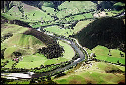
Lower reaches of the Motueka River valley |
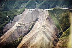
Forest harvesting |
Publications (Selection)
Presentations (Selection)
Primary Contacts:

|
Les Basher
Email Phone: 03 545 7708 Fax: 03 546 1082 More details» |
Institute Landcare Research |
Expertise Soil science, geomorphology, erosion processes |

|
Tim Davie
Email Phone: 03 372 7084 Fax: +64 (0)3 365 3194 More details» |
Institute Environment Canterbury |
Expertise Hydrology & modelling, surface water resource management |

|
Andrew Fenemor
Email Phone: 03 545 7710 More details» |
Institute Landcare Research |
Expertise ICM programme management; local liaison; resource management; hydrology and water resource management |

|
Chris Phillips
Email Phone: +64 3 321 9775 More details» |
Institute Landcare Research |
Expertise Erosion processes, slope stability, effects of forestry, catchment management, knowledge management |