Sediment generation, delivery and impacts
Research Status: Ongoing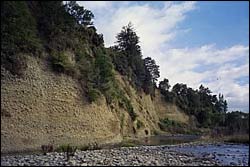 |
Bank erosion - Motupiko River |
Introduction
Sediment may have a range of impacts on the ecology and habitat of both freshwater and marine ecosystems. To understand and manage these impacts it is important to determine the major sources of sediment generation as well as establish changes in riverbed characteristics important to maintenance of the trout fishery, and delivery of sediment to the marine environment.
From 1985 until the late 1990s there was a widespread and significant decline in the abundance and biomass of trout in the Motueka River as measured by drift diving carried out by Nelson-Marlborough Fish and Game and by angler experience. This decline has been linked to increased input of fine sediment into the river and its direct and indirect effects on trout habitat and trout populations. A key property influencing trout populations is the proportion of sand and silt in the bed of the river, which is believed to have increased in many parts of the river system.
Trout numbers in the Motueka River have rebounded over recent years.
The exact causes of these major fluctuations in trout numbers is not well known scientifically. There is little data on riverbed characteristics throughout the Motueka, variation in rates of sediment supply, the time scale for sediment movement through the river system, the major sources of sediment and the relative role of natural erosion and that related to land-use (forestry or pasture), and the long-term impact of large storms.
Previous scientific work on sediment has focused largely on sediment generation from forestry activities on Separation Point Granite. This has demonstrated earthworks associated with roads and landings are the main sediment producing areas and landslides are the biggest sediment contributors. However, on a whole catchment basis (such as the Dart or Wangapeka) natural erosion rates are higher than those induced by disturbance. Recommendations to reduce disturbance-related erosion included regulation of landing size, regulation of roading and cutbank formation, safe storage of excess sidecast material, avoidance of stream crossings by use of appropriate culverts, and promotion of revegetation.
Recent discussions with a range of people with interests in sediment issues in the Motueka suggest there are a variety of factors influencing present sediment characteristics of the Motueka River including the long-term impact of large storms, sediment generation from both natural erosion and that related to forestry activities on Separation Point Granite, the long-term impact of past forestry management practices, and river bank stability.
Research Approach
To establish changes in riverbed characteristics important to maintenance of the trout fishery, and to determine the major sources of sediment input and options for managing the rate of sediment supply.
- Characterise particle size composition in stream beds throughout the Motueka catchment and establish permanent sites for ongoing monitoring of changes in stream bed character
- Attempt to reconstruct past stream bed character from air photo analysis, anecdotal evidence and TDC river cross-section data.
- Determine major sources of sediment input into the Motueka River from air photo analysis and field survey
- Analyse trends in suspended sediment concentration using available data
- Incorporate a sediment sampling strategy into the Environmental Sampling Network
- Link with riparian/in-stream investigation sites.
Research Results
A number of reports and documents have been produced covering suspended sediment monitoring, changes in river bed cross-sections, bank erosion, gravel extraction, river bed substrate characterisation, and the impacts of fine sediment on biota.
One of the other things to be done has been to produce a report that outlines the conceptual issues which need to be addressed in developing an erosion-sediment model for the Motueka catchment. It is based on analysis of sediment dynamics within the Motueka catchment resulting from the sediment source mapping that has been undertaken, and the findings of the review of the effects of fine sediment on river biota.
Intensive monitoring of turbidity and flow has been undertaken at 4 sites in the Motueka catchment from December 2002 to November 2009. This data has been used to calculate sediment yield on a storm event and long term basis. The following data sets were updated in June 2010 and archived:
- Description of data collection and archiving .
- A summary of data on a storm event basis. These are estimates based on the event-yield ratings fitted to the data collected during intensive monitoring from 2002-2009, and extrapolated using long-term flow records.
- Daily suspended sediment loads from 1/12/02 to 30/11/09 .
- Long-term suspended sediment yield estimates including an analysis of error in these estimates.
 |
 |
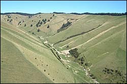
Kikiwa - erosion from Easter 2005 flood |
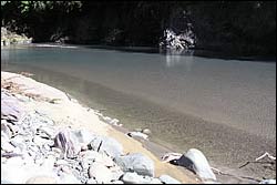
Fine sediment at Motueka Gorge from Easter 2005 flood |
Recent Publications
Recent Presentations
BMPs, BEPs and Guidelines
| Title | Description |
| Gravel Extraction Guidelines – Wellington | |
| Soil Conservation Technical Handbook | The Soil Conservation Technical Handbook is a comprehensive collection of know how about soil conser...More » |
| Clean Streams: A Guide to Managing Waterways on Tasman – Marlborough Farms |
From booklet: This booklet provides information about how to manage waterways to improve water...More » |
| New Zealand Environmental Code of Practice for Plantation Forestry | The E CoP is an essential tool for anyone involved in forest management. Developed by the NZFOA, and...More » |
| Erosion and Sediment Control Guidelines Canterbury | |
| Shelter for Hill Country Farms: Part 2 shelterbelt trees |
From Booklet: Once you have decided where a shelterbelt will be planted see Environment Topic ...More » |
| ANZECC Guidelines for Sediment | A chapter fron the ANZECC guidelines pertaining to sediment...More » |
| Controlling Gully Erosion with Debris Dams | A guide for building debris dams to stabilize gully erosion....More » |
| Small Flood Detention Dams | Guide for the construction of detention dams for flood control....More » |
| Protecting Infilled Valley Bottoms from Gullying | A guide to controlling gully erosion....More » |
Primary Contacts:

|
Les Basher
Email Phone: 03 545 7708 Fax: 03 546 1082 More details» |
Institute Landcare Research |
Expertise Soil science, geomorphology, erosion processes |

|
John Dymond
Email Phone: 06 353 4955 |
Institute Landcare Research |
Expertise land and water models, GIS, remote sensing |

|
Chris Phillips
Email Phone: +64 3 321 9775 More details» |
Institute Landcare Research |
Expertise Erosion processes, slope stability, effects of forestry, catchment management, knowledge management |