Delta habitat mapping
Research Status: Past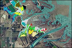 |
Habitat map |
Introduction
Prior to this investigation, very little information was available describing intertidal and shallow subtidal habitats of the Motueka River delta. Therefore baseline description was required in order to understand natural dynamics and the effects of human activities in the catchment.
Research Approach
Mapping of the delta and the idenfication of habitat types assists in understanding the interaction and connection between terrestrial and marine ecosystems, particularly in this case where the Motueka River does not have a typical estuary. Point in time baseline mapping enables comparison with existing historical photographs and future repeat comparisons as a measure of change (e.g. in response to flood events).
Research Results
There has been a significant loss of rushlands and associated habitat surrounding the Motueka River delta between 1947 and 1986. Anecdotal evidence suggests an even greater loss occurred prior to 1947. There was little change between 1986 and 2001. Habitat losses appear to be due to stopbanking, flood gates and land drainage. These changes are likely to have had a significant negative impact on resident and migratory fish populations.
There are patches of stable boulder/mud/sand habitat off the motueka River mouth containing ecologically significanf horse mussel populations.
 |
 |
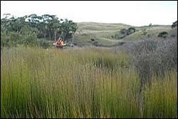
Jointed wire rush |
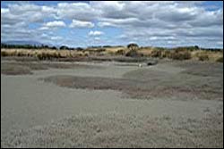
Glasswort |
Recent Publications
Recent Presentations
| Year | Title | File Size |
| 2007 | Changes in estuarine habitats due to coastal developments: Examples using GIS habitat mapping. | |
| 2005 | Intertidal and Subtidal Habitats of the Motueka River Delta. |
|
BMPs, BEPs and Guidelines
| Title | Description |
| Community–based Dune Management for the Mitigation of Coastal Hazards and Climate Change Effects: A Guide for Local Authorities |
From manual: This manual brings together lessons from existing and successful dune care/resto...More » |
| Turning the Tide: An estuaries toolkit for New Zealand communities | Toolkit produced by NZ Landcare trust coordinators Gretchen Robertson and Monica Peters for the Taie...More » |
Primary Contacts:
|
|
Kim Clark
Email |
Institute Cawthron Institute |
Expertise Marine scientist, ICM technical support, marine ecology |

|
Paul Gillespie
Email Phone: 03 548 2319 Fax: 03 546 9464 |
Institute Cawthron Institute |
Expertise Estuarine & marine microbial ecology |