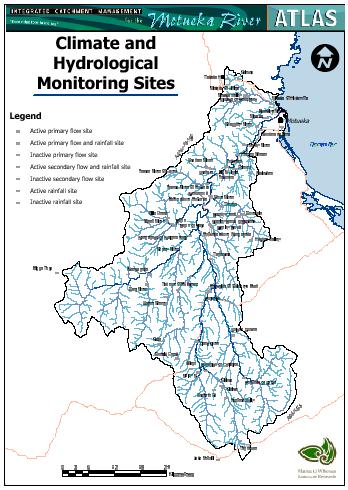
Currently climatic data are recorded by NIWA (the National Institute
for Water and Atmospheric Research) at Riwaka (rainfall, air, grass and
earth temperature, wind run, vapour pressure and radiation), Graham
(rainfall), Motupiko (rainfall), Tapawera (rainfall), and Lake Rotoiti
(rainfall, air, grass and earth temperature, vapour pressure).
Tasman District Council record rainfall at Woodman's Bend, Woodstock, the upper Motueka
Gorge, Baton Flats, Wangapeka (at Walters Peak), Tadmor (at Mudstone),
Motupiko (at Christies), and Biggs Tops (immediately adjacent to the
Wangapeka headwaters).
Landcare Research record rainfall at Donald Creek in Big Bush
Forest.
NIWA also holds historical rainfall data for Motueka (1899-1985),
Riwaka Valley (1947-1998), Kairuru (1961-1979), Takaka Hill (1947- 1959),
Dovedale (1947-1985), Thorpe (1959- 1981), Stanley Brook (1911-1983),
Hogden Valley (1947-1955), Baton (1952-1998), Wangapeka (1924-1928 and
1963-1996), upper Sherry River (1913-1923), Golden Downs (1929-1980),
Atapo (1947-1955), Kaka (1947- 1998), Kikiwa (1947-1965), and Tophouse
(1913-1931 and 1961-1971). |
|
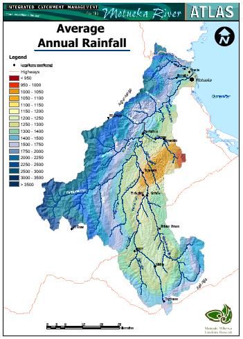
Mean annual rainfall for the catchment is estimated at 1600 mm.
However, there is a strong spatial pattern of rainfall variation,
primarily related to topography.
Rainfall ranges from <1000
mm/yr on the eastern side of the catchment to about 3500 mm/yr in the
headwaters of the Wangapeka.
Annual rainfalls in the mountainous,
western tributaries are far higher (1500-3500 mm/yr) than in the eastern
tributaries (1000-1400 mm/yr), and within the main valley rainfall
increases slightly from the coast (c. 1300 mm/yr) to the headwaters (c.
1500 mm/yr).
Rain falls on average between 100 and 150 days per
year, increasing at higher elevation to 200 rain days per year.
The
northerly aspect and western ranges shelter the catchment from severe
westerly storms, except in the headwaters of the Baton and Wangapeka
catchments. |
 |
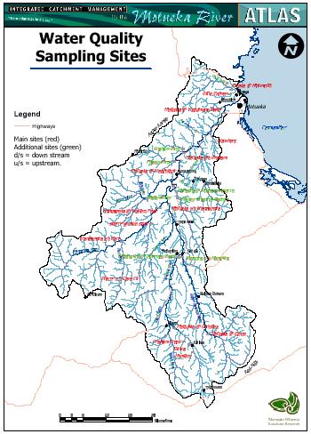
| As part of the ICM Programme an environmental sampling network has been
initiated to provide an improved understanding of the variation in water
quality through the catchment, and of the influence of land use and geology
on water quality.
This network provided monthly values over a 13-month period for a range
of chemical and biological parameters (dissolved oxygen, temperature, water
clarity, turbidity, total suspended solids (as inorganic and organic
fractions), conductivity, pH, dissolved reactive phosphorus, total
phosphorus, nitrogen (as ammonia, nitrate, total nitrogen), Enterococci
coli, total faecal coliforms, and Campylobacter).
The network continues to be monitored quarterly as part of the Tasman
District Council's State of the Environment monitoring.
Sixteen main sites and seven additional sites were chosen to cover a
longitudinal profile of the river, and sample the key geological types
(ultramafic rocks, basement rocks, Moutere gravels, Separation Point
granite, marble), land uses (native forest, production forest, mixed
agriculture, dairying, horticulture) and stream sizes found throughout the
catchment. |
 |
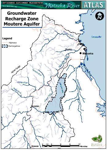
| Groundwater in the Motueka Plains groundwater system is contained within
alluvial gravels (known as the Motueka gravels) forming the coastal delta of
the Motueka and Riwaka rivers.
This system is the principal source of water for irrigation, industrial
and domestic use on the Motueka Plains, supplying 85% of the current water
used.
The Motueka gravels are thinnest (c. 6 m) at the inland margins of the
plains, and thicken to 30 m in the central plains area.
The gravels are cleanest and most permeable in the central plains, and
become less permeable where mixed with fines (from Moutere gravels) to the
south and with colluvium and organic materials to the west and north. |
 |