Gravel extraction
Research Status: Ongoing |
River survey |
Introduction
Periodic cross section surveys are the main tool used by councils to allocate gravel extraction from rivers bed by considering:
- trends in mean bed level (MBL) and gravel storage
- estimates of gravel extraction
- estimates of long-term rate of gravel supply.
There has been debate about trends in MBL, changes in gravel storage within the Motueka, and the influence of gravel extraction on those trends.
Research Approach
River cross-section data are the main way in which volumes of gravel are calulated. For the Motueka River a comprehensive analysis of all data using a consistent methodology was completed in which mean bed levels and volume of gravel stored in the river channel through time were calculated changes.
The gravel volume changes were compared with gravel extraction rates, and the influence of gravel extraction on trends in riverbed levels determined.
Alternatives to cross section analysis were also considered.
Research Results
- Compiled all river cross-section and gravel extraction data for the Motueka River
- Provided a comprehensive analysis of all data using a consistent application of “end area”methodology
- Masters thesis comparing different methods of analysing cross section data
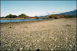
- Detailed work using GPS surveys at the 3 beaches reach gravel extraction site near Tapawera to monitor change following “over-extraction”, and to assess how well cross-sections represent river behaviour
- The river bed is degrading resulting in a loss of channel storage of gravel: Upper Motueka (1960-2004)-0.33 m; Lower Motueka (1978-2001)-0.34 m
- Superficially much, but not all, the change in gravel storage can be accounted for by gravel extraction
- There are large error limits on the gravel storage volume changes derived from cross sections
- The cross sections probably underestimate the total gravel storage volume changes (and gravel transport)- don’t account for spatial variation between the cross-sections; don’t account for temporal variation between surveys
 |
 |
Gravel beach |
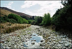
Low flow in Stanley Brook |
Recent Publications
| Year | Title | File Size |
| 2012 | A Summary of Outcomes and selected formal publications from the Integrated Catchment Management (ICM)research programme:2000 – 2011 |
|
Recent Presentations
BMPs, BEPs and Guidelines
| Title | Description |
| Using Gravel Extraction to Restore Backwaters | Guidelines for creating backwaters...More » |
| Gravel Extraction Guidelines – Wellington | |
| Best practice guidelines for vegetation management and in stream works | These best practice guidelines cover activities undertaken by the River and Catchment Services group...More » |
| Gravel Extraction to Create Backwaters | Draft guidelines to create backwaters, channels, oxbow lakes etc....More » |
| Using Gravel Extraction to Restore Floodway Ponds | Guidelines for restoring floodway ponds...More » |
| Using Gravel Extraction to Restore Oxbow Lakes | Guidelines for restoring oxbow lakes for flood protection...More » |
| Using Gravel Extraction to Restore River Channels | Guidelines for river channel restoration for flood control measures...More » |
Primary Contacts:

|
Les Basher
Email Phone: 03 545 7708 Fax: 03 546 1082 More details» |
Institute Landcare Research |
Expertise Soil science, geomorphology, erosion processes |
|
|
Eric Verstappen
Email Phone: 03 5438417 |
Institute Tasman District Council |
Expertise river & coastal science, engineering & management |