Guidelines for assessing gravel extraction volumes
To effectively regulate and monitor gravel excavation information is needed on
- trends in gravel supply
- river bed levels
- and excavation rate data through time.
These data can be used to set and adjust extraction levels according to gravel supply and to estimate the proportion of gravel supply that can be sustainably harvested without having significant in-stream and downstream effects. River bed levels and excavation rate data are relatively easy to collect, while trends in gravel supply are more difficult to estimate.
One of the most difficult issues is estimating sustainable gravel yield. Three approaches have been used to estimate gravel load:
- the morphological method based on conservation of volume
- as a proportion of suspended sediment yield, often derived from NIWA’s suspended sediment yield calculator (http://www.niwa.co.nz/our-science/freshwater/tools#SSY)
- calculation of load from bedload transport formulae.
The morphological method relies on monitoring of bed levels and gravel extraction volumes to allow gravel load to be calculated on a conservation of volume basis over any surveyed river reach. Gravel entering the reach either leaves or remains in the reach so for any reach:
![]()
where: ![]() = change in volume of gravel (m3) over time calculated from riverbed surveys
= change in volume of gravel (m3) over time calculated from riverbed surveys
Qg.input = volume of gravel entering the reach from upstream (m3/yr);
often only able to be estimated from catchment erosion rates
Qg.ext = volume of gravel extracted from the river reach (m3/yr);
derived from gravel extraction returns
Qg.out = export of gravel out of the river reach by downstream transport
(m3/yr)
This provides a minimum estimate of gravel load, with the accuracy of the estimate depending on the frequency of cross-section surveys and the spacing of cross-sections. In reaches with natural deposition zones bed level surveys provide a robust estimate of gravel supply as there is no export of gravel. In rivers with net gravel loss it also requires an estimate of gravel entering the reach which is often only poorly known. This approach can be used to calculate sustainable gravel supply (Ecan 2006).

Fig. 1 Logic diagram for calculating sustainable gravel supply
River cross-section surveys are the primary tool used to monitor riverbed levels and calculate gravel volume changes. Their accuracy for this purpose depends on the spacing of cross sections and frequency of surveys. For rivers with high extraction pressure surveys should be carried out frequently (<5 years). Surveys after significant floods are also useful because these events transport most gravel. Aerial photos and site inspections can also be used to supplement the information from cross sections and provide an indication of river behaviour between the cross sections. Increasingly GPS, LIDAR, or digital photogrammetry will provide an additional tools for creating digital elevation models and more accurately estimating gravel volume changes (Fig. 2).
Gravel extraction volumes can be derived from resource consent applications or contractor’s returns. The latter provide a far better estimate of the gravel actually removed from the river.
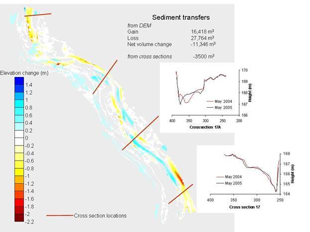
Fig. 2 Comparison of gravel volume changes from cross sections and DEMs. The cross sections are about 600 m apart; the DEM is derived from a GPS survey with c.5 m grid spacing.
Key criteria to determine the appropriate monitoring regime for managing gravel extraction in a river are:
- sensitivity of the reach (taking account of trends in riverbed changes shown by existing bed-level monitoring data and/or assessments of sediment supply)
- extraction pressure
- flood risk
- presence of sensitive infrastructure (bridges, water intakes, pylons, etc.)
- potential impact on groundwater levels
- bed and bank stability
- ecological sensitivity.
References
Environment Canterbury 2006. Regional gravel management report. Report R06/1. Environment Canterbury, Christchurch.