Modelling water quantity and quality
Research Status: Ongoing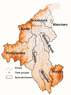 |
Motueka catchment (above Woodstock) as used in SWAT |
Introduction
The aim of this research is to develop numerical models that describe the hydrological behaviour of the Motueka catchment and can be used to investigate management issues identified by stakeholders.
Research Approach
In the early stages of the research programme John Dymond and Robbie Andrew developed a distributed hydrological model (DHVSM) for the Motueka catchment (Dymond & Andrew, 2006). The model has been used to simulate the impacts of land cover change in the catchment.
Following a review of different modelling approaches (see report; Davie 2004) the main modelling effort has concentrated on using SWAT (Soil and Water Assessment Tool) to model water quantity and quality.
Research Results
The SWAT model (Cao et al paper) and DHVSM (Dymond & Andrews paper)have both sucessfully modelled Motueka river flows and then been applied to different land use change scenarios. Initial use of SWAT for nitrogen dischrage from the catchment was discouraging (see report) however subsequent calibration of controlling parameters (particularly the rate nitrogen transfer through lateral flow) has started to produce more meaningful results.
Work is ongoing, particularly in producing simulations for IDEAS.
 |
 |
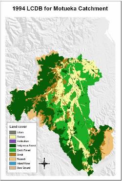
1994 land use within the Motueka catchment |
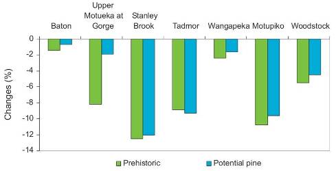
Modelled changes in annual water yield in subcatchments with different land covers (compared to present) |
Recent Publications
Recent Presentations
| Year | Title | File Size |
| 2003 | Application of SWAT in a large mountainous catchment with high spatial variability. | |
| 2001 | Water Balance of the Motueka River Catchment. | |
Primary Contacts:

|
Tim Davie
Email Phone: 03 372 7084 Fax: +64 (0)3 365 3194 More details» |
Institute Environment Canterbury |
Expertise Hydrology & modelling, surface water resource management |

|
John Dymond
Email Phone: 06 353 4955 |
Institute Landcare Research |
Expertise land and water models, GIS, remote sensing |

|
Jagath Ekanayake
Email Phone: 03 321 9656 |
Institute Landcare Research |
Expertise Landslide modelling, soil physics instrumentation, SWAT modelling |