Long term in–situ data collection in Tasman Bay
Research Status: OngoingData buoy |
Introduction
The Motueka River plume outwelling region of Tasman Bay has been characterized through a series of synoptic surveys of water column and seabed properties/processes. Such point-in-time investigations, however, do not adequately demonstrate either the evolving effects of short term variation in river flow/composition (e.g. flood events) or the longer term implications of changing weather patterns (e.g abnormal wet or dry periods) on coastal ecosystem processes. Long term data collection is therefore a prerequisite to filling in the gaps in our understanding of the effects of catchment activities on the river plume ecosystem.
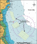
A buoy-mounted, in situ, real time data collection facility was therefore deployed in the plume-affected region of western Tasman Bay. The buoy station is located 6 km offshore from the Motueka River mouth and has subsequently been adopted by the Tasman District Council as a State of the Environment (SOE) monitoring site. The station was purposely established at a point 1 km from the outer boundary of an aquaculture management area proposed for long line culture of GreenshellTM mussels.
Research Approach
Hourly midwater measurements of current speed & direction, conductivity, temperature, depth, chlorophyll a and turbidity are telemetered to Cawthron to automatically update data files and graphics. Additional surface and bottom water sensors are included to identify stratification characteristics, and variation in the quality of the feeding environment for scallops is assessed with near-bottom chlorophyll a and turbidity sensors.
Research Results
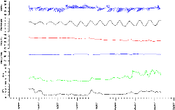
Over the one-week period, 15-22 March 2007, we observed a 2ºC decrease in seawater temperature (18.5-16.5 ºC). This temperature decline seemed to signal the onset of a brief autumnal phytoplankton bloom with a series of chlorophyll a peaks of up to ~7 mg/m3.
A short sharp rainfall event was captured 23-24 May that resulted in a slight decrease in midwater temperatures and salinities along with a distinct peak in turbidity. It took about 12 hours for the suspended sediment plume to reach the buoy.
 |
 |
Map of buoy location |
Autumn algal bloom March 2007 |
Recent Publications
BMPs, BEPs and Guidelines
| Title | Description |
| Tonga Island Marine Reserve: Proposed protocol for ongoing subtidal biological monitoring | This document presents a proposed protocol for ongoing monitoring of the Tonga Island Marine Reserve...More » |
Primary Contacts:

|
Reid Forrest
Email Phone: 035482319 |
Institute Cawthron Institute |
Expertise Sediment geochemistry |

|
Paul Gillespie
Email Phone: 03 548 2319 Fax: 03 546 9464 |
Institute Cawthron Institute |
Expertise Estuarine & marine microbial ecology |