Riparian vegetation assessment
Research Status: Past |
Native riparian vegetation |
Introduction
One of the important aspects of riparian management to aid improvement in freshwater habitat is to assess the nature of the existing riparian vegetation and explore opportunities for vegetation enhancement - particularly with native vegetation.
Research Approach
A pilot catchment, the Sherry River, was chosen to explore ways of mapping current vegetation and identify where the best places might be for native vegetation enhancement.
A method was designed to classify riparian vegetation using the Tasman District Council colour orthophotographs to describe riparian vegetation in seven broad classes. Ground truthing corrected misinterpretations. The vegetation in the non-pasture classes was assessed to provide a description of the vegetation and an understanding of the opportunities for enhancement.
Research Results
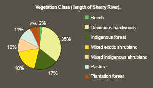
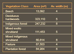
11% of the length of the Sherry River is pasture and has no woody riparian vegetation. Over a third of the riparian vegetation has been classified Deciduous hardwood. Deciduous hardwood vegetation is generally about 5 m wide and consists mainly of crack willow trees draped in old manís beard. It often has a thick ground cover of blackberry. Weed management is essential if more desirable riparian vegetation to be established.
The mixed indigenous shrubland vegetation is in the upper part of the catchment, and contains some native species such as kanuka and coprosmas.
Indigenous forest exists along about 17% of the length of the river and consists of beech and podocarp trees, some native understory species, with few weeds present. This vegetation has an average width of 6 m. Individual beech trees also occur intermittently along the length of the river. These areas offer good opportunities for riparian enhancement with native species. Weed management will be less difficult, and a native seed source already exists.
Riparian enhancement considerations
- Adjoining land management objectives
- Potential riparian values
- Proximity to native vegetation
- Stock exclusion
- Weed and pest management
- Willow management/removal
- Use of nurse crops
- Planting/seeding of natives
- Community motivation.
 |
 |
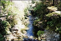
Sherry River vegetation |
Sherry River vegetation |
Recent Publications
BMPs, BEPs and Guidelines
| Title | Description |
| Riparian Zone Management Guidelines |
From document: This Guideline is a practical manual for use by landowners, developers, organis...More » |
| Riparian Zone Management Planting Guide | Companion Guide to "Riparian Zone Management Guidelines"...More » |
| Native Plants for Streamsides in Wellington Conservancy |
Guideline helps reduce further loss of indigenous biodiversity by indicating the native plants ...More » |
| Streamside Planting Guide |
From website: The streamside planting guide will help you know what to plant where, and how to...More » |
Primary Contacts:

|
Lisa Langer
Email Phone: 03 364 2949 Fax: 03 364 2812 |
Institute Ensis (formerly Forest Research) |
Expertise Riparian vegetation |