IDEAS
Research Status: Ongoing |
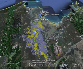
Google Earth visualisation of IDEAS scenario |
Introduction
The purpose of IDEAS is to provide an Integrated Dynamic Environmental Assessment System within which modelling tools provide answers to real catchment questions about cumulative causes and effects of a mosaic of catchment developments. IDEAS is a strategic planning tool for testing “futures scenarios” involving a triple bottom-line approach, a collaborative learning development process, and assessment of cumulative effects in land and water management.
Research Approach
IDEAS needs to feed information into the dialogue between stakeholders so that a shared vision of the catchment can be generated. Stakeholders will need to know the present status of the catchment, in terms of environmental, economic, and social performance, and will also need to know how this changes with various catchment management scenarios.
A challenge in the development of tools for ICM is ensuring they are fully utilised beyond the development phase by stakeholders. To meet this challenge IDEAS has both a social and technical stream of work associated with development. The technical stream is concerned with the linking of models to come up with a technical package. The social stream uses a participatory approach to ensure stakeholder knowledge is incorporated into the technical stream, to set parameter thresholds and design scenarios, and to ensure users understand the inherent assumptions within the models used. The technical and social aspects together are called IDEAS.
Within the technical stream of work the biophysical models predict the flow of water, and associated sediment, carbon, nutrients, and pollutants, through the catchment and into the marine environment. Inputs to the models will be spatial data (land use is time dependent). Outputs from the models will be time-dependent digital maps of mass flows (water, carbon, nutrients, and pollutants). No one model is able to handle all of the processes of interest in the catchment, so we plan to use several models of what we judge to be the important processes and to link them.
The mass flows from biophysical models are linked into socio-economic models through biophysical coefficients. The socio-economic models comprise aspatial and spatial components. The aspatial component is called the Catchment Futures Model and is an economic input-output model coupled with a population growth model. It may be used in a temporal mode where yearly environmental and economic outcomes influence sector drivers for following years. The spatial component is Evoland. It models individual agents on the landscape and how policy, and environmental and economic outcomes influence individual land use and management decisions. It may be used to assess the influence of policy and education of actors on future land use patterns. Within IDEAS Evoland is predominantly used as a possible land-use scenario generator; allowing evaluation of policy and agent values on possible catchment futures. These are then used as the basis for biophysical model simulations within the catchment (e.g. SWAT) and in the coastal marine area which evaluate the environmental fluxes within possible land-use scenarios.
Research Results
A variety of catchment scenarios have been evaluated for socio-economic and environmental outcomes. These include (1) pre-human (2) present land use (3) present land use with best management practice (4) very intensive agriculture (5) very intensive agriculture with best management practice, and (6) continued present growth until 2020. While the socio-economic measures of scenario (4) may be satisfactory, the environmental measures indicate problems with high nitrogen concentration in river water and lack of water for irrigation. Indeed, the indicator of low flow (low flow minus maximum allowable water take) implies that in times of drought the river could actually dry up. IDEAS does not provide a framework for conflict resolution, but through its integration it identifies focussed points of disagreement, on which further research and more detailed models, outside of the integrative framework, are often required. In future, climate change will be incorporated into catchment planning deliberation by modifying explicit climate variables in the bio-physical models.
These results are summarised in the IDEAS presentations below.
The IDEAS data link (2.25 MB) - a spreadsheet that links the biophysical models with the socio-economic models to provide scenarios. Note: this will be continuously updated as modelling outputs are refined.
Added: 30 June2009. This version includes Garth Harmsworth's "Cultural Score".
Added: 23 March 2009. This version includes Roger Young's trout modelling and revised E.coli analysis. There is also an explanation of the assumed erosion cover factors for exotic forest in the sheet "present".
Recent Publications
Recent Presentations
Primary Contacts:

|
Will Allen
Email Phone: 03 321 9600 More details» |
Institute Landcare Research |
Expertise participation, multi–stakeholder processes, participatory evaluation, networking |

|
Chris Batstone
Email More details» |
Institute Cawthron Institute |
Expertise resource economics |

|
John Dymond
Email Phone: 06 353 4955 |
Institute Landcare Research |
Expertise land and water models, GIS, remote sensing |

|
Ben Knight
Email More details» |
Institute Cawthron Institute |
Expertise Biophysical systems specialist |