Catchment Overview
Details
| Physical features | Topography |
| Major lakes and bays | Seasons and climatology |
| Major river and waterways | Land-use and land cover |
| Hydrologic budget | Marine resources |
| Geology | Population |
| Hydrogeology | |
|
 |
| Atlas & Maps | Technical Report |
Summary
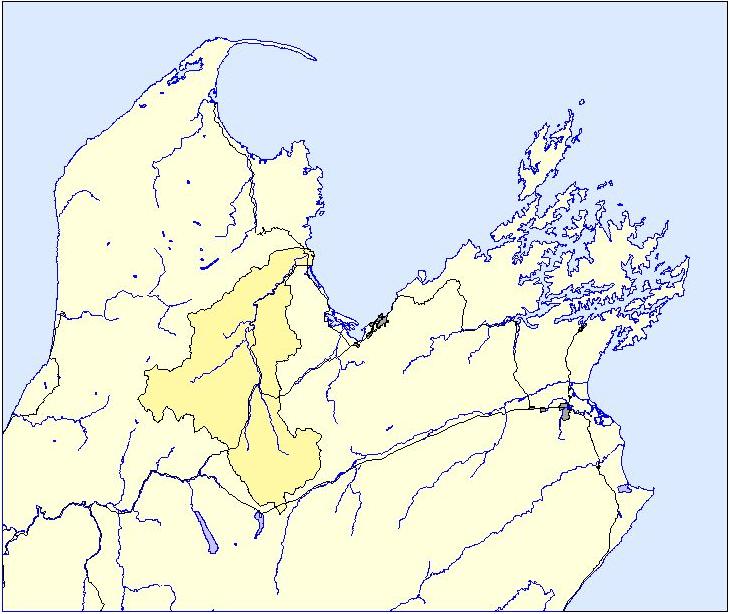
The Motueka River catchment is about 2,200 km2 and is located in the north west of the South Island of New Zealand. The Motueka River rises in elevation from sea level to 1600 m in alpine headwaters and delivers 95% of the fresh water to Tasman Bay, a productive and shallow coastal body of high cultural, economic, and ecological significance.
Average annual precipitation is about 1300-1550 mm, the annual discharge of the Motueka River is 844 mm, and mean annual flow is 58.1 m3 s-1. The climate is cool and humid with distinct wet and a dry (austral summer) seasons.
The geology is mixed with clearly defined terranes which include erodible granites (mid-basin), clay-bound gravels (mid-basin), ultra-mafic mineral formation (eastern headwaters), sandstone-siltstone (eastern headwaters), and complex limestone, marble, and calcareous mudstone (western headwaters).
The alluvial plains in different parts of the catchment support a wide range of horticulture on young relatively fertile soils, much of which is irrigated from groundwater aquifers. Rolling and steep hill country in the lower basin contain low-fertility soils and are grazed or in plantation forest, while the rugged mountainous terrain in the headwaters with a mixture of thin-infertile to thick fertile soils are mostly in native "bush"conservation estate.
The Motueka river supports a nationally significant brown trout fishery and annual surveys of over the last 6 years have consistently shown that the observed number of adult trout were about one third of the numbers seen in 1985.
.jpg)
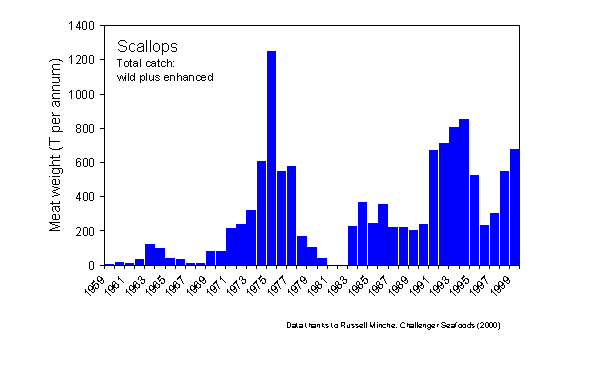
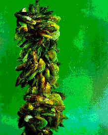
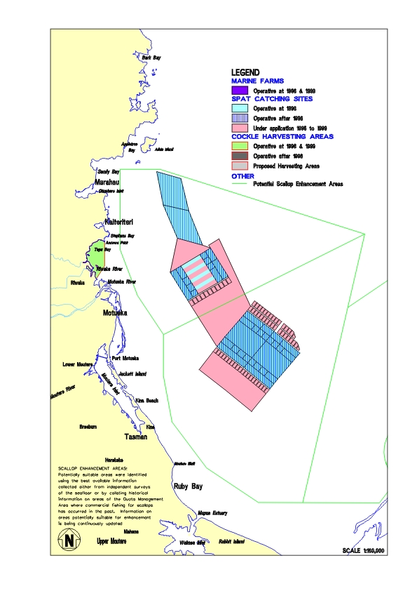
Nationally significant scallop and cockle fishery are key activities in Tasman Bay and there is a rapidly expanding mussel farming and aquaculture industry.
The catchment is sparsely populated with less than 1 person per km2 with the biggest town Motueka, containing 12,000. Populaiton growth is moderate at about 2% per annum. Maori, the indigenous people of the area, have a strong interest in the management of the catchment and Tasman Bay, and have a marae in Motueka township.
Physical Features
-
Total catchment area 2,170 km2
-
Located between 41o00’ S and 41o45’ S latitude, and 172o30’ W and 173o00’ W longitude (map)
- Entirely within the boundaries of the Tasman District, South Island, New Zealand.
- Elevation: sea level at Tasman Bay to 1600 m in alpine headwaters
- Length: 110 km
- Breadth: 18 km near the mouth to 50 km at the headwaters
- Average depth: <1 m
- Delivers 95% of the freshwater inflow to Tasman Bay
Major Lakes and Bays
- No major lakes
- Motueka River discharges into a Tasman Bay, a productive and shallow coastal body of high cultural, economic, and ecological significance.
Major Rivers and Waterways
(* =long term flow records)
- Motueka River *
- Important west flank tributaries (Riwaka *, L. Sydney, Brooklyn*, Shaggery, Rocky, Pokororo, Graham, Pearse)
- Important east flank tributaries (Waiwhero*, Orinoco, Dove)
- Major headwater tributaries:
- Baton *
- Wangapeka *, including the Dart and Sherry
- Tadmor *
- Motupiko*
- Upper Motueka*
- Stanley Brook *
Hydrologic Budget
- Average annual precipitation: 1300-1550 mm gauged over catchment 3500+ mm estimated in mountainous regions
- Number of rain days >1mm: 102-137
- 50-year, 24-h rainfall event: 141-229 mm
- Annual sunshine hours: ~2400 h
- Annual pan evaporation: 1105 mm
- Annual days of air frost: 31-92 days
- Annual discharge from the Motueka River: 844 mm
- Mean annual flow: 58.1 m3 s-1
- Mean annual 7-day low flow: 9.6 m3 s-1
- 50-year flood event: 2050 m3 s-1 (Note: the last 4 values are for the catchment to Woodstock, not the whole 2200km2)
Geology
- erodible (Separation Point) granites (mid-basin)
- clay-bound Pliocene-Pleistocene (Moutere Depression) gravels (dominant, mid-basin)
- ultra-mafic (Dunn Mountain) mineral formation (eastern headwaters)
- sandstone-siltstone (Maitai Group) formation (eastern headwaters)
- complex limestone, marble, and calcareous mudstone (Mt Arthur Group) formations (western headwaters)
Hydrogeology
- alluvial plains aquifers (horticulture):
- upper aquifer (1-10 m depth, transmissivity 2000 m3/day/m)
- middle aquifer (10-16 m depth, transmissivity >4000 m3/day/m
- lower aquifer, (>16 m depth, transmissivity >2500 m3/day/m)
- Moutere gravels (horitculture, forestry): 3-120 m3/day/m
- Alluvial valley aquifers (dry land pasture, dairy, horticulture): probably like upper plains aquifer (i.e., 2000 m3/day/m, decreasing away from the river.
- Mountain calcareous complexes: high and unknown (sinkholes, caverns).
Topography
- Flat alluvial plains at mouth, sea-level, young relatively fertile soils
- Rolling and steep hill country in lower basin, low-fertility soils
- Flat alluvial terraces in upper basin valleys, young relatively fertile soils
- Rugged mountainous terrain in headwaters, ranging from thin-infertile to thick fertile
Seasons & Climatology
- Cool, humid with distinct wet and a dry (austral summer) seasons
- Dry season can lead to water shortages on dominant Moutere Gravels
- Climate is affected by:
- Air masses from Tasman Sea (westerly, warm), South Pacific (northerly and easterly, moderate), and Southern Ocean (southerly, cold).
- Orographic effects are pronounced.
- Location of the basin within a small island mass, situated within a temperate zone.
- Shelter of the western mountain
Land-use & Land cover
- Native "bush" in headwaters: southern beech (Nothofagus), podocarps (1/3)
- Commercial forestry on steeplands: radiata pine, Douglas fir (1/3)
- Dry land pasture: pasture grasses, sheep and,
- Valley bottom riparian areas: berry crops, hops and,
- Coastal plains: fruit trees, hops (= remaining 1/3)
Marine resources
- Nationally significant scallop and cockle fishery: dredging
- Potential for expanding mussel farming: aquaculture
- Recreational and commercial fin fisheries
Population
- Sparsely populated: less than 1 person per km2
- ~12,000 in catchment, mostly in the town of Motueka
- ~40,000 in Tasman District (1996 NZ Census)
- Moderate growth: ~2% per annum
- History of settlement
- Social and cultural setting
Pressures on Water Resources
- Water withdrawals (largely irrigation)
- Surface water: 132 permits (761 L s-1)
- Groundwater: 335 permits (1,715 L s-1)
- Permits for discharges into Motueka River:
- Low: 10 of 136 in the greater region
- Type: largely stormwater and dairy
- Stream and river impacts
- Activities relevant to Tasman Bay
- Marine farming: structures, aesthetics, ecological impacts
- Coastal subdivision and development
- Coastal hazards: erosion, flooding
- Coastal structures: marinas, jetties, warves, outfalls
- Nuisance plants and animals, impacts on biodiversity