Landcover and ecological districts
Landcover and ecological districts |
|
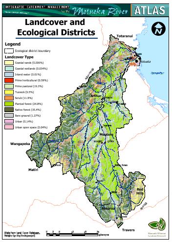
The Motueka Catchment today is largely rural. Current vegetation is dominated by native (35%) and exotic (25%) forest with smaller areas of pastoral grassland (19%), scrub (12%) and tussock grasslands (7%). The only significant urban centre is the township of Motueka. Small but ecologically significant areas of wetland are found at the coast and scattered throughout the catchment. The largest areas of native forest are found in the headwaters of the western tributaries (Kahurangi National Park) and in the upper catchment (Mt Richmond Forest Park). Commercial production forests (mainly radiata pine, with smaller areas of Douglas fir) occupy large areas of the steeper and less fertile soils on both Moutere gravel and Separation Point granite. Scrubland, dominated by fern, gorse and manuka, occurs throughout the catchment, mainly on the poorer soils on steep hill country. Scrub reversion is a major challenge for pastoral farming in many parts of the catchment. Pasture grassland generally occupies the lower and easier slopes of the Moutere Depression, the west-bank tributaries, and the river flats and terraces. Horticulture is limited to the river flats and terraces, and makes up only 0.6% of the catchment area. |
|